


Etang de Lers Tuc de Laguel

pidjam
User
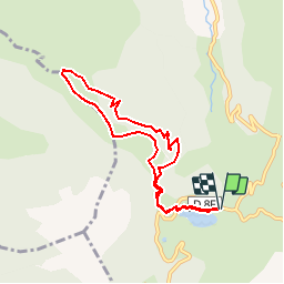

Length
7.9 km

Max alt
1626 m

Uphill gradient
399 m
Km-Effort
13.3 km

Min alt
1268 m

Downhill gradient
399 m
Boucle
Yes
Creation date :
2018-06-26 15:22:11.438
Updated on :
2018-06-26 15:22:11.438
2h00
Difficulty : Easy

FREE GPS app for hiking
 SityTrail
IGN / Geographical institutes
SityTrail Plus
The world is yours!
About
Trail Other activity of 7.9 km to be discovered at Occitania, Ariège, Le Port. This trail is proposed by pidjam.
Positioning
Country:
France
Region :
Occitania
Department/Province :
Ariège
Municipality :
Le Port
Location:
Unknown
Start:(Dec)
Start:(UTM)
367618 ; 4740805 (31T) N.
Comments